Assessment of coastline change over the last 38 years using satellite EO along Great Britain coast
The project goal is to create a database of coastline position for the whole length of Great Britain (GB) coastlines over the period between 1984 to 2022 (38 years).
The British Geological Survey (BGS) Coasts and Estuaries team use a combination of methods that include the use of innovative 4D simulation models and cost-effective monitoring approaches (i.e. from space and using non-intrusive survey methods) to quantitatively assess the effects of different adaptation options against coastal flooding and coastal erosion with an emphasis in the transition from traditional grey engineering (such as hold the line with hard defences) to more green engineering (a combination of nature based solutions and giving space to coastal processes).
Satellite-borne Earth Observation (EO) is now providing repeated monitoring of the coastline at large scale, high temporal and spatial resolution as well as low cost. It is possible to assess not only the status of the coastline before and after a storm event and before and after each spring tide but also the historical trend since satellite coverage commenced back in 1984.
Supplier: ARGANS Ltd
This project is very relevant not only for BGS’s Coast and Estuaries programe but for all other institutions engaged in informing coastal management decisions in the UK and internationally who are facing today the challenge of managing an increasing risk of coastal flooding and erosion which is likely to increase due to the anticipated Sea Level rise projections in the incoming years
Dr Andres Payo, Head of Coast & Estuaries hazards at British Geological Surve
Andres Payo
British Geological Survey
Natural Sciences
United Kingdom
Earth Observation Services
Several challenges requiring EO professional services
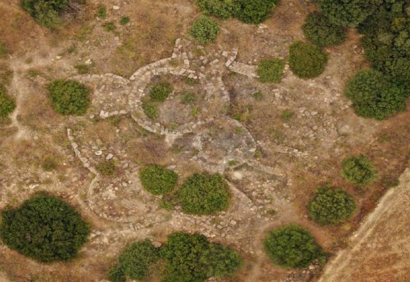
The first challenge is the scale of the task. The length of the entire Great Britain coastline, measured at 10-meter spatial resolution (i.e. resolution of modern Sentinel-2 (S2) satellite optical imagery) is about 17,000 km long. The whole GB coastline is covered by 34 Sentinel and 16 Landsat-5 & 8 (L5 & 8) tiles with the tile size being 100km x 100km and 185-km-cross-track-by-180-km-along-track, respectively. All combined add up to more than 4TB of imagery that need to be pre-processed and analysed. As a result, we will get about 120 waterlines from S2 and about 60 from L5 & 8 per tile.
Anyone who has attempted to extract a waterline from any of the optical satellite imageries available is fully aware that a significant effort needs to be done cleaning the spurious lines from the actual waterline.
The waterlines are snapshots, at the time that the satellite image was taken, and is affected not only by permanent changes of the coastline but also by the water level who changes with the waves, wind, tides and meteorological conditions. To quantify permanent changes of the coastline, decision makers need to separate the variability from met-ocean conditions from the physical coastal changes.
All the above, need to be done with the highest spatial accuracy possible and temporal resolution to capture coastline change events both manmade and naturally occurring.
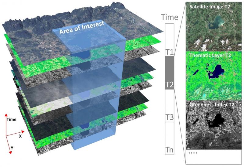
Monitoring coastal change from space as a service
The OCRE EO Service Funding Research enabled BGS to join forces with ARGANS Ltd., a leading service provider in a fast-developing market of EO as a service, to produce a database that covers the entire Great Britain.
ARGANS is setting the standard for coastal change detection products using the different ESA missions (URL coastal Erosion project). The ARGANS led consortium has developed a method to optimise the number of customer ready co-registered waterlines and datum referenced shorelines seasonally covering 25 years that have been validated by the leading geoscience experts within the five partners’ nations. These products deliver inter-pixel accuracy, use a locally adaptive threshold method to accurately determine the position of the land/sea boundary precisely and can be scaled to cover complete nations worldwide. Indeed, each partner nation intends to further expand this work to provide national coverage.
Enabling the translation of EO data into useful and public information to a broad range of coastal stakeholders
We firmly believe that information about coastal change should be made broadly available to the public. Initiatives like the European Space Agency funded Sentinel 1 and 2 missions that make the data publicly available combined with the OCRE program is a great enabler for the public and coastal stakeholders to access coastal change information.
The value of this OCRE EO Service funding is on bridging the gap between EO data and information by providing reliable evidence of coastal change for the whole Great Britain.
Contact us
Now that the OCRE Project has ended as of 31/12/2022, please contact GÉANT for any enquiries.